
🗺️ The route
Free to viewHarboro Rocks is a limestone outcrop above Brassington in the Derbyshire Dales, with a short climb to a 379 metre summit and views over Carsington Water. We only planned a quick outand back, but ended up spending a good two hours poking around the top, in and out of the cave and puzzling over the carved rocks, before finishing at the trig point for the obligatory tap and then straight back down.


What to expect
The rocks are a dolomitic limestone hill, a popular spot for climbers doing top rope and bouldering routes, with short pitches of 6 to 12 metres. The ground is grazing land for local farmers, so stick to the paths and keep dogs under control around livestock.
It’s a quiet spot, we barely saw anyone else up there. The ground underfoot is rocky and uneven if you go off path but there is a clear footpath right to the top, but do take your time as you’re making your way there.


Getting there & parking
There’s a small free car park right by the rocks, just off the B5056 south of Longcliffe. For a longer walk, you can also start from Brassington village.
Good to know
No, there aren't any on this route.
On lead only.
Expect rocky Terrain underfoot. What we wear for it ↓
The route
- 0.8 Miles
- 1-2 Hours
- Easy–Moderate
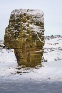
From the car park it’s a short, steep climb up to the summit, out and back the way we came. We spent a good while exploring around the rocks: there’s a cave built into the rocks; occupied since the Ice Age, it features rich archaeological history. In 1726 Daniel Defoe wrote about a poor family of seven living happily inside the cavern whilst the father was working as a local lead miner. On the top near the trig we found a rock that had been carved out we had no idea what it was until we got home and looked it up, and it turns out it was used as a font, and in 1906 a local farmer’s baby was actually baptised up here with water from it. We finished at the trig point for the obligatory tap before heading back down.
Step-by-step
- From the car park turn right and walk steadily dow the road
- You will see the footpath sign on your right immediately follow that and pass the factory
- You will then come across the high peak trail
- From here you will see an old farm building and the path will be going to the right of this
- Follow this straight up and explore the area!
- To get back just reverse and repeat
Your walk
Heading out? Take this walk with you
Free members get the tools to follow it on the day, so you're not relying on phone signal.
- GPX downloadFor your phone, watch or Komoot.
- Printable route cardOne page with the route, pit stops and an emergency line.
- Track it & get the stampTick it off and add the miles to your log.


Tips & what to bring
Sturdy footwear for the rocky, uneven summit, and take care near the edges if you’re climbing up for the view. There are no facilities at the rocks, so bring water. It’s grazing land, so keep dogs under control and shut any gates behind you.
What we'd pack for this walk
See how we wear it →Kit we actually use, picked for this route.
-
Grip on rock We both wearLa Sportiva TX4
Grippy, supportive approach shoe we wear on rockier Peak trails.
-
When the weather turns Ads wearsRevolutionRace Waterproof Jacket
Bright, fully waterproof shell for proper British weather. Ads' go-to in the orange.
-
Room for water & snacks Char usesDeuter Speed Lite 23
Lightweight, low-bulk pack for fast, lighter days.